SPECTACULAR HIGH ALTITUDE PASSES
OF HIMACHAL [ I ]
PIN PARBAT
The massive Pir Panjal range of the Greater Himalaya separates the districts of Kullu and
Lahaul-Spiti in Himachal Pradesh. There are a number of rugged passes along this range which the
hardy tribals have used since time immemorial- Kugti, Chobia, Kalicho and
Rohtang served the residents of Lahaul, while Hamta and Pin Parbat were used by
the people of Spiti. Inevitably, with the expansion of the road network and improved connectivity, these passes now witness the passage
of only the resilient “gaddis” or the adventurous trekker.
At 5319 meters Pin
Parbat straddles the watershed of Kullu and Spiti: the north is drained by the
mysterious Pin river, and the south by the Parbati. Pin Parbat also separates
two distinct eco zones: the Kullu side is blessed with lush green temperate
vegetation while the northern Spiti side is a cold desert devoid of any
vegetation, a frozen canvas of sculpted rocks and lonely peaks bathed in the
most colourful hues imaginable. The pass
can be approached from both sides but the route from the Parbati valley on the
Kullu side is the more preferred option.
.jpg)
[ The infant Parbati exiting Mantalai lake. Photo by author ]
The launch point for
the ascent to the pass is the glacial Mantalai lake (14000 feet), the source
of the Parbati river and a three days’ trek from the road head at Pulga in the
Parbati valley. There is no human habitation after Khir Ganga, a day's trek from Pulga, and the only
peoples you can expect to meet thereafter are the itinerant, nomadic and transhumant
Gujjars or Gaddis with all their worldly assets literally on the hoof, guarded
by that matchless breed of dogs – the eponymous gaddi or Himalayan Sheep Dog. It is possible to reach the pass from Mantalai
in one day’s hard trekking and climbing, but this is not adviseable because it
involves a climb of 4000 feet and then a descent of another 3000 feet to the camp-site on the other side, all over
rocks, ice and crevasses. Any delay and one can get stranded in dangerous no
man’s land in the darkness. It is best, therefore, to camp at the foot of the
pass after leaving Mantalai and push up to the pass the next day.
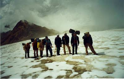
[ On the saddle of Pin Parbat pass. Author is fourth from the right.]
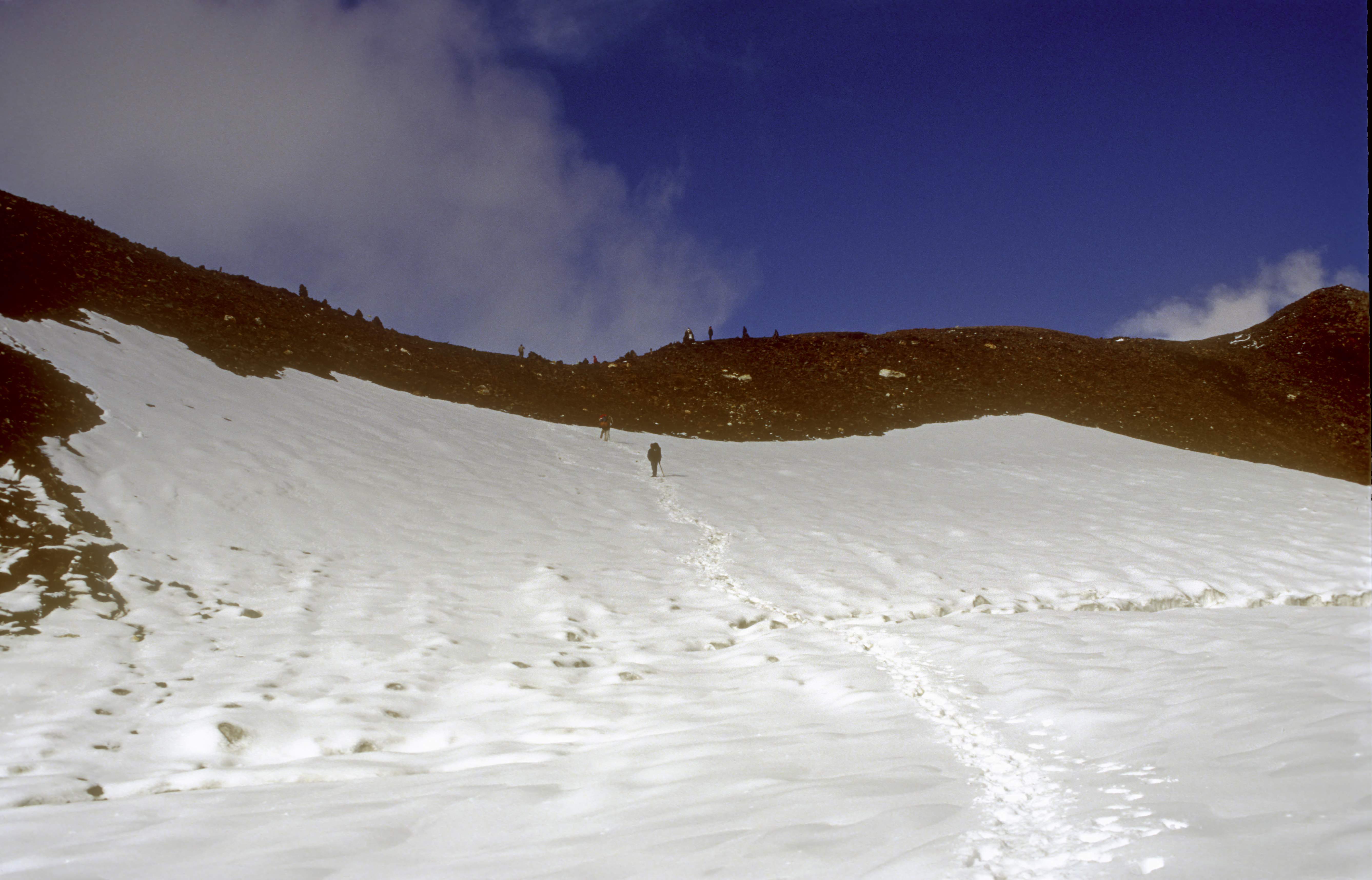
The track from the lake heads
east along a narrow, detritus filled valley overhung with glaciers on both
sides which feed the lake itself. It ends about three kilometres later at an awe-inspiring feature: a
sheer wall of loose rock and moraine, rising straight up 1000 feet at an
impossible angle of 70 degrees. It’s difficult to get a firm footing on this
slippery slope and one has to inch up one step at a time, keeping a lookout for
falling boulders. It takes two hours to
reach the top: at 15000 feet the view is stupendous- a 270 degree sweep from
the west to the north, an unending array of glaciers, peaks and shimmering
streams, all feeding the forbidding lake which we had just left behind.

[ The massive snout of a glacier on the way to the Pass. Photo by author ]
The track continues eastwards from the saddle, along a
narrow, scree covered valley floor, through which flows another small stream
originating from the glacier atop Pin Parbat itself. We followed this rivulet
for a couple of kilometres and then pitched camp for the night- Base camp I.
The next day dawned bright and crisp as only the mountains
can offer. We broke camp at 7.00AM, and after a kilometre came to a huge
rockfall about 50 meters high which would extend all the way to the pass. The
going is tough, but soon relieved by the snout of a massive glacier on the
right, at least 150 feet high. It was an awe-inspiring feature as we moved
along its foot: it had ice caves and overhangs from which little ribbons of
snow melt emerged in hundreds of cascades, all merging into the little stream
we were following. Soon we were above the glacier and could now see its huge
expanse from the top. It stretched away as far as the eye could see to the
south, and it was fractured with hundreds of crevasses. I sometimes wonder if
this immense glacier is still there, or if it too has succumbed to the effects
of global warming.

[ The colours of Pin valley. Pin river is in the middle ground.
After another kilometre or so, the top of the rockfall is achieved, and the Pin Parbat pass itself now rises on the ridge-line, completely encased in a thick mantle of ice. This ice crust is about 10 feet thick at the edge. We clambered over it; the prospect before us was absolutely mesmerising: wave upon wave of ice dunes, hillocks and shallow valleys of snow and ice on the massive glacier, gently ascending to the pass itself. There is no track and the surface is fractured with innumerable crevasses. The snowfall of the previous night had covered these fissures with a light mantle of snow, obscuring them from the careless trekker and presenting an additional danger. Carefully roped up, we trudged through the vast ice field and after about an hour crested the top of the glacier. This is indeed glacier land- all around us were these massive rivers of ice and we counted at least 12 of them. We were now standing on the exact watershed line between Kullu and Spiti, looking down into the little known Pin Valley, taking its name from one of the streams originating from the pass- the Pin river. Base camp II was a further 1000 exhausting meters below. From Base camp II, which is on the banks of the infant Pin it is another two days’ trek to the little village of Mudh. This is the Pin Valley National Park, the domain of the snow leopard, Spiti wolf, ibex and ghoral.
An unknown English Alpinist has helpfully listed the primary identification of a high altitude trekker.
ReplyDeleteThe doctor holds a flashlight to one ear and examines the other. If light is seen exiting it, he is a natural climber.
One is envious of Avay Shukla for belonging to this ethereal group of individuals, who have it in them to climb and climb, simply because - in the words of George Mallory - “the mountain is there.”
Every now and then when Mr. Shukla unwraps a jewel from his treasure trove of high treks, one is transported to the tall ranges and massifs of Himachal.
Vicariously, of course. It is said of the snowy carnivores that they know who the weaker trekker is!
Waiting for more, Sir.
What a myriad of colours in what one would imagine to be a bleak landscape.. Treacherous and enticing in their formidable, majestic allure to become a lifelong passion of ye Dil maange mor.... Can't get enough of such a narrative... It whets the wanderlust like nothing else
ReplyDeleteThroughout my day, I pray to you, let there be hills to climb,
ReplyDeleteThere is scant zest in mastering the plains,
For loitering, for rest, there will be time,
When daylight wanes.
Dear Lord, Let my horizon ever be a hill,
Which I must reach although the trail be steep;
Up, up to climb with energy and will before I sleep.
For when I reach the summit on a hill,
I’ll find my dreams guarding the topmost peak,
The sun will set, the air be calm and still.
And God will speak.
Not in a valley let me end my day;
I would have heights to gain a clearer view:
Therefore for hills I pray and strength to climb,
Dear God to you....
-------------------------------
(from the Prayer Book of St. Paul's School, Darjeeling, (est. 1823)
For Avay especially.
ReplyDeleteDidn't mean to speed anyone on his or her way. Just thought the essay brought the essence of the prayer closely to heart.
ReplyDeleteA very poignant and truthful prayer, Kabir. Guess it says everything.
ReplyDeleteAnd don't worry; one's going nowhere soon! In the words of Gulzar:
" Ahista chal Zindagi,
Abhi kai karz chukana baaki hai,
Kuch dard mitana baaki hai,
Kuch farz nibhana baaki hai....."
Amen.
DeleteAnd thanks. Aff.
ReplyDelete